Entrusted by Guangdong Province Archaeology Institute,Department of Marine Science and Engineering, Southern University of Science and Technology、Social Science Center of Southern University of Science and Technology、Jiataike (Shenzhen) Technology Co., Ltd.In Guangdong ProvinceHuidong County carried out"Drone aeromagnetic isfieldsExploration projects applied in archaeological remains surveys".
The technical method of this project was first proposed by Professor Liu Qingsong from the Magnetism Center of the Department of Marine Science and Engineering, Southern University of Science and Technology.WillSectionVbl.CenterProfessor Gao Dalun provides application guidance andThe purpose is to use a high-precision magnetometer mounted on a drone platform to carry out ultra-low-altitude drone aeromagnetic measurements, infer the spatial distribution characteristics of underground soil composition and shallow structures in the target area, and provide basic data for archaeological site selection.It is supplemented by ground sampling and borehole sampling to provide underground soil magnetic parameter analysis to confirm the inference.
viaGuangdong Province Archaeology InstituteDesignate possible remains sites and makeUsing the product developed by Jiatai (Shenzhen) Technology Co., Ltd.The GTK-RF-M300 drone aeromagnetic system collects aeromagnetic data from ultra-low-altitude multi-rotor drone in designated areas.groundSamples were used to measure relevant magnetic parameters using various high-precision measurement instruments at the Magnetism Center of the Department of Marine Science and Engineering, Southern University of Science and Technology. After corresponding data processing, map preparation and data analysis of aeromagnetic data, combined with sampling analysis and other dataprove, drone aeromagnetic dataThe results can well reflect the response of the magnetic source body in the measurement area,The unknown magnetic source body anomalies in the magnetic trap provide a reference target area for the next step of investigation and excavation.
The application of drone aeromagnetism in archaeological remains investigation is an exploration and attempt to apply new technologies and new methods to the traditional comprehensive research discipline of archaeology. Combined with drone photography, surveying, and three-dimensional imaging technologies, data acquisition extends from the ground to underground structures.As a basic technical means, it has certain application value and can provide technical support for future field archaeological surveys.
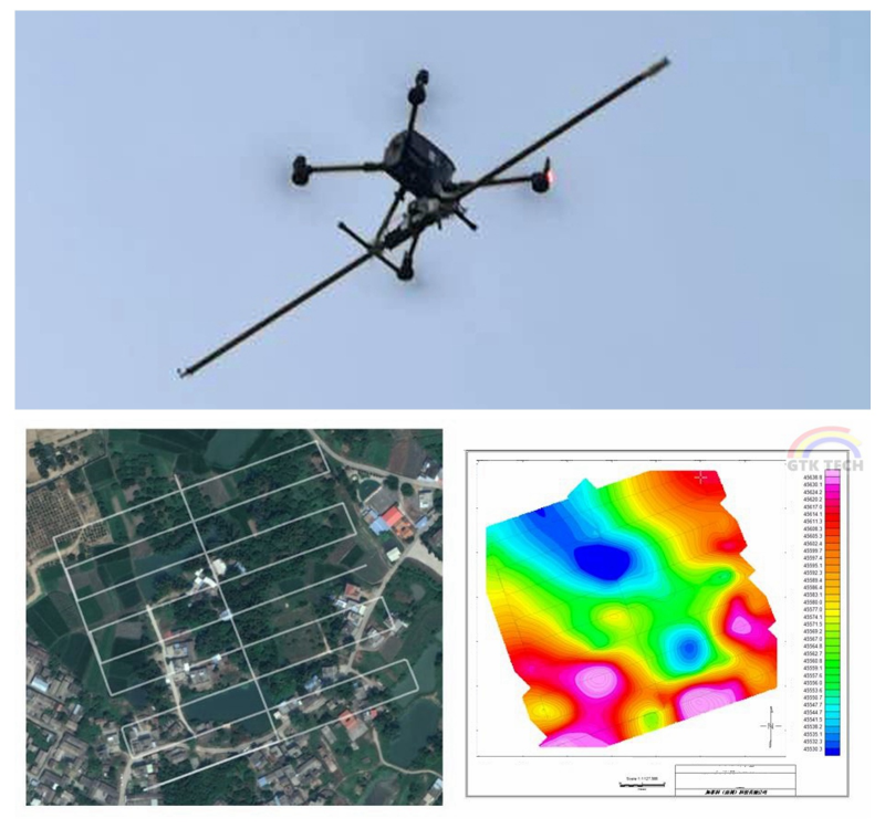
figure I.Unmanned aerial vehicle aeromagnetic systemand aeromagnetic survey lines and magnetic fieldcontour gridFigure
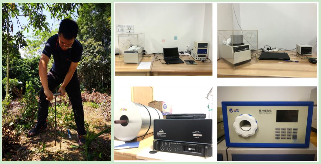
figure II. Ground sample collection and high-precision laboratory magnetic measurement instrument
