Jiataiko (Shenzhen) Technology Co., Ltd. equipped with DJI M400 in aeromagnetic equipment: embarking on a new journey of aeromagnetic exploration
In many fields such as geological and mineral exploration, geological scientific research, geological disaster assessment and emergency rescue, high-precision and efficient aeromagnetic detection is crucial. Relying on its innovative spirit, Catalico (Shenzhen) Technology Co., Ltd. successfully combined advanced aeromagnetic equipment with the industry-level flagship flight platform DJI Matrice 400, bringing breakthrough solutions to related industries.
Strong alliance, full of advantages
DJI M400 lays the foundation for excellent performance
Ultra-long battery life and powerful load: DJI Matrice 400 has an amazing 59-minute long battery life (loaded flight) and a load capacity of up to 6 kilograms. In aeromagnetic detection missions, long battery life means that it can cover a larger detection range and reduce the time loss caused by frequent battery replacement; its strong load-carrying capacity allows Catalico aeromagnetic equipment to be stably mounted, whether it is in a vast area. The M400 can easily respond to large-scale surveys in plains or fine surveys in complex mountainous areas, ensuring that aeromagnetic detection missions are completed efficiently.
Top obstacle avoidance and precise positioning: It integrates circular scan laser radar, six-direction millimeter wave radar and fisheye vision to achieve wire-level obstacle avoidance. In the process of aeromagnetic exploration, complex terrain and obstacles are common challenges. The M400's obstacle avoidance system can keenly sense the surrounding environment, automatically avoid obstacles, and ensure flight safety. At the same time, its precise positioning system provides accurate acquisition of aeromagnetic data. Provide reliable guarantees to ensure that the equipment flies stably on a predetermined route and obtain high-precision aeromagnetic data.
Ultra-long image transmission and intelligent functions: Support O4 image transmission industry enhanced version and aerial image transmission relay, with a transmission distance of up to 40 kilometers, allowing the operator to control flight status and aeromagnetic data in real time even at a long distance. In addition, the M400 also has powerful intelligent functions such as visible light and thermal imaging model detection, AR projection, and ship take-off and landing. With rich automated operation capabilities, it can operate stably in various complex environments, providing more opportunities for aeromagnetic detection. possibility.
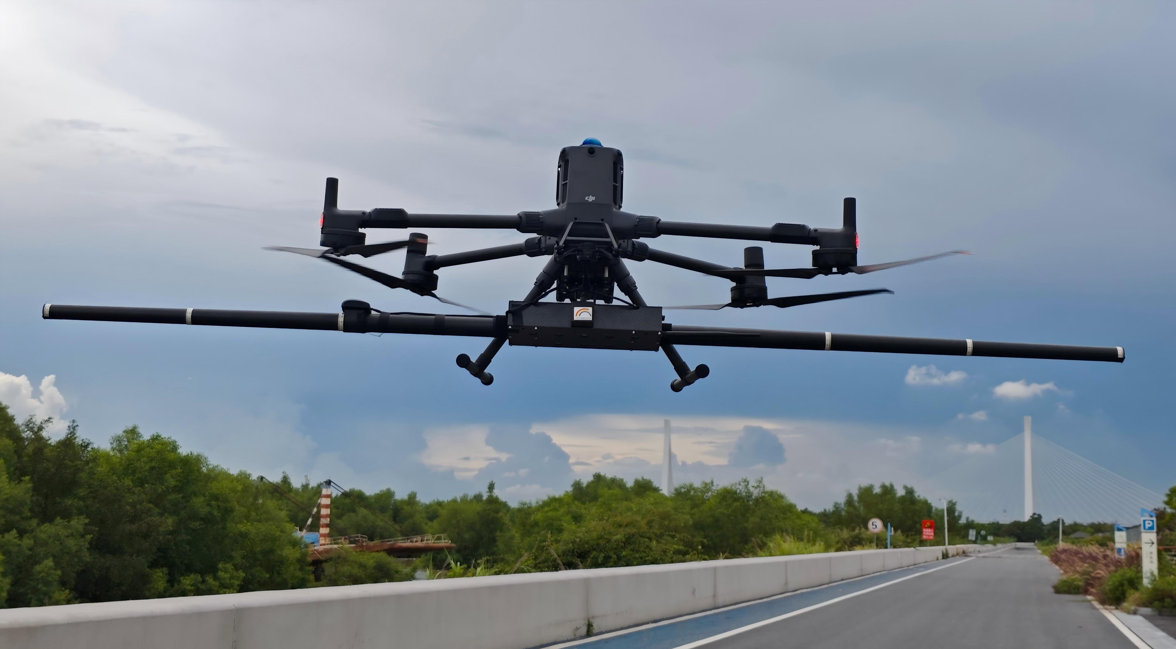
Empowering the core technology of Catalco aeromagnetic equipment
Advanced aeromagnetic measurement technology: Catalco introduces advanced technology from Canada and continues to innovate on this basis. Its aeromagnetic equipment adopts aeromagnetic optical pump and fluxgate dual compensation technology, and integrates a high-precision rubidium optical pump magnetometer and a high-precision fluxgate three-component magnetometer. During flight, whether it is interference caused by aircraft maneuver or magnetic field interference caused by complex geological environment, the interference can be effectively removed through real-time or post-flight compensation methods using software compensation, thereby obtaining extremely accurate aeromagnetic data, providing a reliable basis for geological analysis.
Comprehensive sensor integration: In addition to magnetometer, it is also equipped with multiple sensors such as GPS, laser altimeter, and 9-axis attitude sensor. GPS ensures accurate recording of the flight trajectory, laser altimeter measures the flight altitude in real time, and 9-axis attitude sensors accurately sense the attitude of the aircraft. These sensors work together to ensure the accuracy and stability of aeromagnetic data collection in all directions, making the detection results more scientific and reliable.
Widely used, helping development in multiple fields
geology and mineral exploration and
When looking for potential mineral resources, the Catalico aeromagnetic equipment equipped with the DJI M400 can quickly and efficiently conduct aeromagnetic measurements on large areas. By analyzing high-precision aeromagnetic data, geologists can clearly identify abnormal changes in underground geological structures, accurately locate areas where minerals may exist, greatly improve the efficiency and accuracy of mineral exploration, reduce exploration costs, and provide strong support for the country's mineral resources.
geological scientific research
For geological science research, an in-depth understanding of the earth's internal structure and geological evolution processes is crucial. This combined equipment can obtain detailed aeromagnetic data, help scientists study the change laws of the Earth's magnetic field, analyze the formation and evolution of geological structures, provide rich data support for the development of earth science theories, and promote the continuous development of geological science research.
Local disaster assessment and emergency rescue
After geological disasters such as earthquakes and landslides occur, rapid assessment of the scope and extent of the disaster is crucial for rescue work. Catalco's aeromagnetic equipment equipped with DJI M400 can quickly fly to disaster-stricken areas. It obtains underground geological structure information through aeromagnetic detection, analyzes possible hidden dangers of secondary disasters, provides scientific decision-making basis for the rescue team, and helps carry out rescue work quickly and effectively. To minimize casualties and property losses.
The perfect combination of aeromagnetic equipment and DJI M400 is a model of technological innovation and practical application. Relying on the superior technologies of both parties, they provide efficient and accurate aeromagnetic detection solutions in many fields, which will surely play an important role in the future development of the industry and lead the field of aeromagnetic detection to a new height.
