-
-
wechat:同手机
-
-
Email:sales@gtktech.com
Contact Information
Official account of Wechat
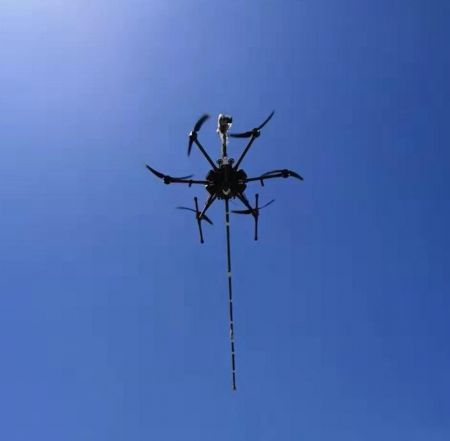
GTK-RF-M300 omnidirectional obstacle avoidance +RTK GPS quad-rotor drone aeromagnetic system (optically pumped fluxgate aeromagnetic)
With horizontal gradient and three-dimensional vector magnetic field measurement capabilities, It has ultra-low-altitude flying capabilities and is suitable for small targets such as archaeology,UXO project
usingA miniaturized high-precision civil rubidium optical pump magnetometer developed by MEMS technology
Ground static noise level: ≈0.01 nT (fourth-order difference method,2Hz sampling)
Dynamic airborne noise levels:≈0.07nT (fourth-order difference method,2Hz sampling)
Resolution:0.0001nT
sensitivity: 0.02nT/√Hz (0.1-100 Hzfrequency band, power spectrum)
measurement dead zone: Single declination plane,± 7 degrees
Measuring range: 1000 nT - 100000 nT
Power supply and power consumption: 5V,3W
Operating temperature: -30C to +60C
Calibrating: No need
Probe size: 19x19x47 mm (probe)
Probe weight: 18 g (probe)/100g(frequency counter) (excluding connecting wires)
response speed: 10000 nT/s
maximum gradient tolerance: 1000 nT/cm
High-precision fluxgate magnetometer
number of flux gate axes 3 (right-hand XYZ coordinate system)
Measuring range ±100μT
Internal noise: low noise InAt 1Hz, ≤10pTrms/√Hz
preheating time 15 minutes
offset error In zero-field±5nT
linear error 0.0015%(least squares fit)
Temperature coefficient of offset error ±0.3nT/℃
quadrature error The axle error is less than±1°
Digital output static noise level <0.06 nT/1Hz
Dynamic flight compensation effect 1-2nT(5Hz, typical)
Micro multi-channel data collector
CPU ARM Cortex-A53 1.2 GHz quad-core
Memory 1GB
Interface USB 2.0 interface 4 x USB Ports,GPS,10/100M Ethernet interface
Power input: 5V 2.5A
rated power: 800mAH(4.0W)
Overall size: 100 x 60 x 40mm
Weight:190.5g (excluding connecting wires)
Function: Data acquisition, optically pumped aeromagnetic,high precisionGPS (2m) receiving module collects geographical location information
9-axis accelerometer gyroscope attitude angle measurement module/barometer
Laser Altimeter
supply voltage 5V
average current ≤180mA Peak current ≤180mA
average power ≤0.9W Weight 77g
Range: 180m@90% reflectivity, 70m@10% reflectivity,130m@90% reflectivity &100Klux, 50m@10% reflectivity &100Klux
Operating temperature -25~60℃ Storage temperature -40~85℃
Protection gradeIV IP67
Catalco Self-developed Aeromagnetic Ground Station
The company develops its ownThe Windows platform Catalco aeromagnetic survey data receiving and processing software provides automatic and manual planning of satellite map survey points land-simulated flight, digital elevation survey point planning, daily variation correction, data merge, real-time/post-flight display of data, data cleaning, data output, aeromagnetic compensation and other functions.
Giving drones automatic measurement and flight for aeromagnetic operations can effectively avoid risk points and improve operation efficiency. Combined with the company's patented aeromagnetic compensation technology, field operations and engineering production can be truly realized.
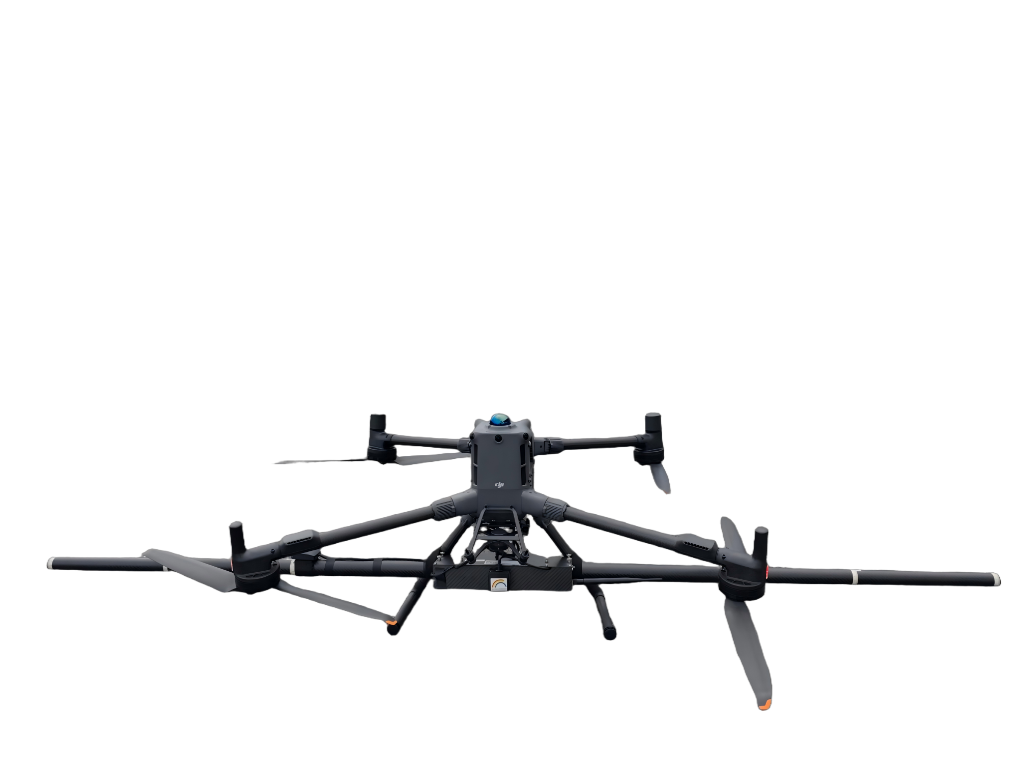
dajiang M300 RTK flight platform
maximum load | 2.7 kg |
Recommended maximum takeoff weight | 9kg |
Hovering accuracy (P-GPS) | Vertical: ±0.1 m (during normal operation of visual positioning) ±0.5 m (during normal operation of GPS) ±0.1 m (during normal operation of RTK positioning) Horizontal: ±0.3 m (during normal operation of visual positioning) ±1.5 m (during normal operation of GPS) ±0.1 m (during normal operation of RTK positioning) RTK position accuracy at RTK FIX: 1 cm+1 ppm (horizontal) 1.5 cm + 1 ppm (vertical) |
Maximum tolerable wind speed | 15 m/s (Class 7 wind) |
maximum flight time | 55 min |
maximum takeoff altitude | 5000 m (2110 blade, take-off weight ≤7 kg)/ 7000 m (2195 plateau silent blade, take-off weight ≤7 kg) |
Obstacle perception range | Front, rear, left and right: 0.7-40 m up and down: 0.6-30 mFOV front and down: 65 ° (H), 50° (V) left and right upper: 75° (H), 60° (V) The surface of the use environment has rich texture, sufficient lighting conditions (>15 lux, indoor fluorescent lamp normal illumination environment) Infrared sensing system obstacle sensing range 0.1-8 m |
working environment temperature | -20℃ to 50℃ |
IP protection level | IP45 |
charging time | When using the 0 smart battery box, use a V power supply: It takes about 60 minutes to fully charge two TB60 smart flight batteries,It takes about 30 minutes to charge from 20% to 90% |
GTK-RF-M300 omnidirectional obstacle avoidance +RTK GPS quad-rotor drone aeromagnetic system (optically pumped fluxgate aeromagnetic)
With horizontal gradient and three-dimensional vector magnetic field measurement capabilities, It has ultra-low-altitude flying capabilities and is suitable for small targets such as archaeology,UXO project
usingA miniaturized high-precision civil rubidium optical pump magnetometer developed by MEMS technology
Ground static noise level: ≈0.01 nT (fourth-order difference method,2Hz sampling)
Dynamic airborne noise levels:≈0.07nT (fourth-order difference method,2Hz sampling)
Resolution:0.0001nT
sensitivity: 0.02nT/√Hz (0.1-100 Hzfrequency band, power spectrum)
measurement dead zone: Single declination plane,± 7 degrees
Measuring range: 1000 nT - 100000 nT
Power supply and power consumption: 5V,3W
Operating temperature: -30C to +60C
Calibrating: No need
Probe size: 19x19x47 mm (probe)
Probe weight: 18 g (probe)/100g(frequency counter) (excluding connecting wires)
response speed: 10000 nT/s
maximum gradient tolerance: 1000 nT/cm
High-precision fluxgate magnetometer
number of flux gate axes 3 (right-hand XYZ coordinate system)
Measuring range ±100μT
Internal noise: low noise InAt 1Hz, ≤10pTrms/√Hz
preheating time 15 minutes
offset error In zero-field±5nT
linear error 0.0015%(least squares fit)
Temperature coefficient of offset error ±0.3nT/℃
quadrature error The axle error is less than±1°
Digital output static noise level <0.06 nT/1Hz
Dynamic flight compensation effect 1-2nT(5Hz, typical)
Micro multi-channel data collector
CPU ARM Cortex-A53 1.2 GHz quad-core
Memory 1GB
Interface USB 2.0 interface 4 x USB Ports,GPS,10/100M Ethernet interface
Power input: 5V 2.5A
rated power: 800mAH(4.0W)
Overall size: 100 x 60 x 40mm
Weight:190.5g (excluding connecting wires)
Function: Data acquisition, optically pumped aeromagnetic,high precisionGPS (2m) receiving module collects geographical location information
9-axis accelerometer gyroscope attitude angle measurement module/barometer
Laser Altimeter
supply voltage 5V
average current ≤180mA Peak current ≤180mA
average power ≤0.9W Weight 77g
Range: 180m@90% reflectivity, 70m@10% reflectivity,130m@90% reflectivity &100Klux, 50m@10% reflectivity &100Klux
Operating temperature -25~60℃ Storage temperature -40~85℃
Protection gradeIV IP67
Catalco Self-developed Aeromagnetic Ground Station
The company develops its ownThe Windows platform Catalco aeromagnetic survey data receiving and processing software provides automatic and manual planning of satellite map survey points land-simulated flight, digital elevation survey point planning, daily variation correction, data merge, real-time/post-flight display of data, data cleaning, data output, aeromagnetic compensation and other functions.
Giving drones automatic measurement and flight for aeromagnetic operations can effectively avoid risk points and improve operation efficiency. Combined with the company's patented aeromagnetic compensation technology, field operations and engineering production can be truly realized.
dajiang M300 RTK flight platform
maximum load | 2.7 kg |
Recommended maximum takeoff weight | 9kg |
Hovering accuracy (P-GPS) | Vertical: ±0.1 m (during normal operation of visual positioning) ±0.5 m (during normal operation of GPS) ±0.1 m (during normal operation of RTK positioning) Horizontal: ±0.3 m (during normal operation of visual positioning) ±1.5 m (during normal operation of GPS) ±0.1 m (during normal operation of RTK positioning) RTK position accuracy at RTK FIX: 1 cm+1 ppm (horizontal) 1.5 cm + 1 ppm (vertical) |
Maximum tolerable wind speed | 15 m/s (Class 7 wind) |
maximum flight time | 55 min |
maximum takeoff altitude | 5000 m (2110 blade, take-off weight ≤7 kg)/ 7000 m (2195 plateau silent blade, take-off weight ≤7 kg) |
Obstacle perception range | Front, rear, left and right: 0.7-40 m up and down: 0.6-30 mFOV front and down: 65 ° (H), 50° (V) left and right upper: 75° (H), 60° (V) The surface of the use environment has rich texture, sufficient lighting conditions (>15 lux, indoor fluorescent lamp normal illumination environment) Infrared sensing system obstacle sensing range 0.1-8 m |
working environment temperature | -20℃ to 50℃ |
IP protection level | IP45 |
charging time | When using the 0 smart battery box, use a V power supply: It takes about 60 minutes to fully charge two TB60 smart flight batteries,It takes about 30 minutes to charge from 20% to 90% |